

Creation Date: 27/06/05 (not confirmed)
Crop: Wheat
Map Ref: SU656965
Reported by: Ellis Taylor/David Schwartman
Image(s): Andrew King/Ellis Taylor/Geoff Ambler/Lucy Pringle(Click to enlarge
images)
 |
 |
 |
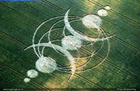
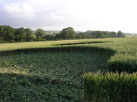
Here are some photos of the crop circle that has appeared near Cuxham, Oxfordshire. I was in it today and it seems to be of a reasonable quality, I couldn't work out the design as it is very complicated and there are no vantage points to get a clear view which is a shame.
 |
 |
 |
Dimensions/Swirl: (Formation to be properly surveyed)
Description and Information (by Ellis Taylor, Darren Watts)
This is my diagram detailing the floor lay of this formation, reported June 28th

Interesting to note that the whole formations 300-400ft length is accurately
positioned & spaced between 5 tram-lines, the geometry and proportions I
think are relative to this. 3 eye catching features include:
A1ft underlying pathway radiating outwards from the central circle delineating
the formations main axis (dowsed energy line running down this, west to east)
A 1ft counter flow on both the crescents inner perimeters
A mistake? where a triangular section of crop which should be standing has
been laid
Looks like the rings were laid first followed by the 7 circles/ requires an
aerial survey
This being my second visit & already the crop is recovering,
good news for
the farmer!
Darren Watts
Magnificent, very large crop circle near Chalgrove in Oxfordshire.
Reported to the Crop Circle Connector. Possibly appeared night of 27th June.
Survey to follow shortly.
Aerial photo certainly required. The design appears to be two interlocking horns with other shapes.
Ellis Taylor